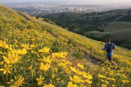
In Salt Lake, some of Utah's best hiking trails start where our downtown ends. Our unique geography puts scenic mountain trails within minutes of city center hotels, making Salt Lake a standout hiking destination for out-of-state visitors. Whether you're planning to tackle steep alpine ascents or looking for family-friendly paths, you'll find trailheads closer than you might expect.
The Wasatch Mountains aren't just a stunning backdrop to our skyline - they're your next adventure, and they're surprisingly accessible. City Creek Canyon's trailhead sits right next to the State Capitol, while Memory Grove Park's scenic paths wind right into downtown. These urban-to-alpine trails are just a quick TRAX, rideshare or GreenBike away from your hotel room. Let's explore some of Salt Lake's most rewarding hiking spots, from easy nature walks to challenging mountain ascents.
Trailheads Right in Town
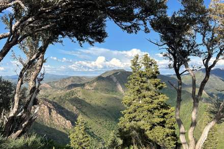
Grandeur Peak
Difficulty: Hard (East), Harder (West) | Best Time to Visit: Sunset from West Route, morning from East Route
Grandeur Peak lives up to its name, serving up some of Salt Lake's most dramatic valley views from its 8,299-foot summit. Here's the fun part: you've got two ways to reach those panoramic views, each offering its own kind of adventure.
The West Route, starting from Wasatch Boulevard, takes the direct approach - gaining 3,000 feet in just 2.5 miles. It's the choice for locals looking for a serious workout or visitors chasing that perfect sunset photo. The trail wastes no time, climbing steadily from the moment you leave your car until you're high fiving at the summit.
Looking for a more gradual journey? The East Route from Church Fork in Millcreek Canyon offers a gentler climb through shaded forest, stretching the adventure to 6 miles round trip. While you'll still reach the same stunning summit, this route treats you to streamside hiking and forest views along the way.
Local wisdom: The West Route faces the sun all day - start early in summer or save it for sunset. The East Route requires a small fee to enter Millcreek Canyon, but the shade makes it worth every penny on hot days.
Mt. Olympus
Difficulty: Extremely-Hard | Best Time to Visit: Sunrise or sunset, Early Spring through Fall
Mt. Olympus isn't just a trail - it's Salt Lake's vertical challenge, rising a dramatic 4,087 feet from valley floor to summit in less than 7 miles. This is where serious hikers come to earn their bragging rights and some of Utah's most spectacular mountain views. While the full 6.9-mile round trip demands respect (and plenty of water), even the first mile delivers panoramic views that'll have your Instagram followers doing double-takes. Looking for Salt Lake's most rewarding sunrise spot? Start hiking in the dark (with a headlamp, of course) to catch the first light from the summit. Or tackle the lower section for a taste of what makes this trail legendary among locals and visiting hikers alike.
Here's what you need to know: The final approach to the summit requires Class 3 scrambling - that means using your hands to navigate steep, exposed rock sections. It's not technical climbing, but it's definitely not your typical trail walk either. First-time scramblers might want to turn around at the saddle and those that do venture on during the winter months, traction devices are required.
Local Wisdom: Pack more water and snacks than you think you need - this exposed trail earns its reputation as one of Salt Lake's most challenging day hikes. But those summit views of the Wasatch Range and Salt Lake Valley? Worth every step.
Red Butte Garden
Difficulty: Moderate (steady uphill sections) | Best Time to Visit: Spring through Fall
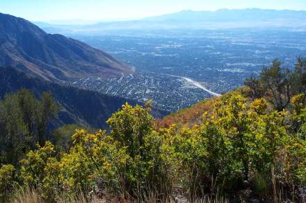
Part of the Red Butte Garden State Arboretum, these trails offer a perfect blend of cultivated beauty and natural wilderness, all within minutes of downtown. While most visitors know Red Butte for its botanical gardens and summer concerts, locals treasure the extensive network of trails that climb into the foothills above the gardens.
The popular 1.9-mile loop delivers surprising variety for its length. You'll climb through native grasslands and oak brush to ridge-top views of the Salt Lake Valley, the University of Utah campus, and the garden's colorful landscapes below. In spring, wildflowers compete with the garden's blooms for attention. Come fall, the mountainside blazes with autumn colors.
For those seeking more challenge, several connecting trails extend deeper into the foothills. The Living Room Trail (a local favorite) and the full Red Butte Ridge Trail offer steeper climbs and longer adventures, with some routes stretching up to 4.5 miles into the Wasatch foothills.
Local wisdom: Time your hike for late afternoon when the setting sun turns the sandstone cliffs golden. Garden members get unlimited access to both the gardens and trails - worth considering if you plan to visit more than twice a year.
Ensign Peak Trail
Difficulty: Easy | Best Time to Visit: Year-round (but watch for snow in winter)
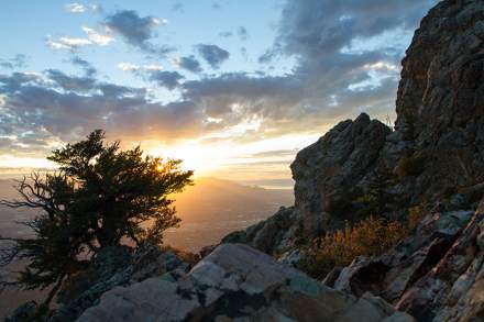
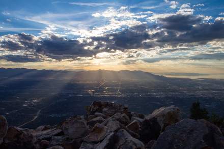
Ensign Peak packs Salt Lake's past and present into one rewarding short hike, serving up valley views that helped shape Utah's history - all within a quick 1-mile round trip from downtown. This is where Brigham Young planned out Salt Lake City in 1847, and today, it's where locals squeeze in lunch-break adventures and sunset photos.
The trail wastes no time - you'll climb steadily for about 20 minutes before reaching the summit marker. With zero shade along the way, this exposed trail can get toasty in summer months, so pack plenty of water and sun protection. Up top, interpretive plaques help you identify everything from the Great Salt Lake to the Oquirrh Mountains. Time your visit for sunset when the city lights start twinkling on below, and you'll understand exactly why Young chose this spot to envision his city.
Local wisdom: Save this hike for a clear day - you'll want clean air for those valley-wide views. And while it's open year-round, bring micro-spikes if you're hiking after a snowfall.
Bonneville Shoreline Trail
Difficulty: Easy to Moderate | Best Time to Visit: Spring through Fall
The Bonneville Shoreline Trail offers more than just a hike - it's a journey along an ancient shoreline where waves once lapped against mountain peaks. Today, this legendary path traces the edge of what was once a massive prehistoric lake, offering some of the most accessible hiking near Salt Lake City. Locals love this trail for morning walks and sunset strolls, thanks to its moderate grade and front-row views of the valley below.
One of our favorite family-friendly access points sits right across from the Hogle Zoo (yes, you can combine a zoo visit with a hike - that's how we roll in Salt Lake). From there, head either north or south, the trail stretches for nearly 100 miles total, but don't worry - you can make this hike as long or short as you like.
Pro tip: Time your hike for sunset and watch as the valley is blanketed by pink, orange and yellow hues.
Pro Tip: Pack a picnic and take a break at one of the scenic overlooks—nothing beats lunch with a view!
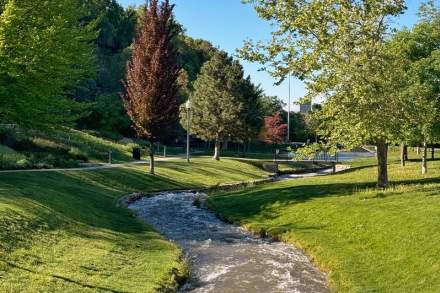
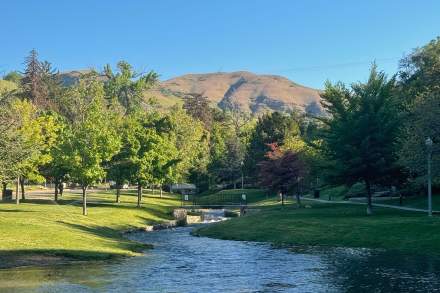
City Creek Canyon Trail
Difficulty: Easy | Best Time to Visit: Late Spring to Early Fall
City Creek Canyon Trail gives 'downtown nature walk' a whole new meaning. Just blocks from Temple Square, this shaded trail follows a mountain stream through a stunning canyon. Pack a lunch and you'll find perfectly placed benches where a variety of animals graze just feet away. The paved lower section makes this one of Salt Lake's most beginner-friendly hiking trails, ideal for families or anyone looking to squeeze a quick mountain moment between meetings.
Local wisdom: Hit the trail early on summer mornings to catch the cathedral-like light filtering through the trees of the canyon. The gentle grade and reliable shade make this a perfect introduction to Salt Lake's hiking scene, especially if you're visiting in July or August.
Note: The canyon is closed Monday to Friday through January 2027 due to ongoing construction. On the weekend access is limited to bikes and pedestrians.
Amenities: Restrooms and picnic areas at the trailhead
Fun Fact: The canyon used to be a water source for early settlers, so you’re walking through a piece of history!
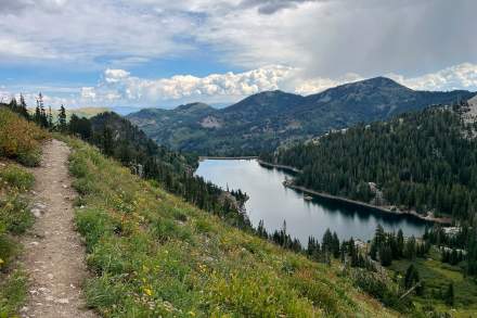
Scenic Mountain Trails Beyond Salt Lake City
Salt Lake's backyard gets bigger and better when you venture just a few miles from downtown. These trails trade city views for alpine lakes, wildflower meadows, and the kind of mountain solitude that makes Utah famous. While they might take a bit more time to reach (we're talking 45 minutes to an hour from downtown), these scenic mountain trails deliver the kind of high-altitude adventure that puts Salt Lake on every serious hiker's map. Pack your camera, bring extra water, and get ready to experience what makes the Wasatch Range legendary.
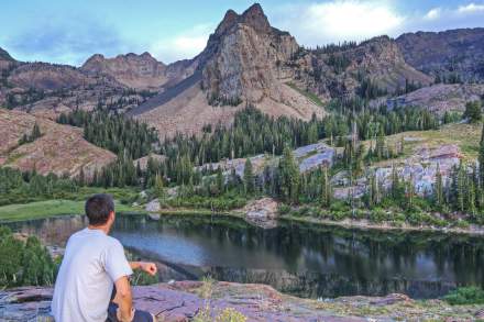
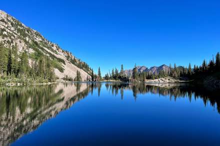
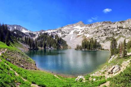
Lake Blanche Trail
Difficulty: Challenging (this one earns its views) | Best Time to Visit: July-September for wildflowers
Lake Blanche isn't just another pretty alpine lake - it's the crown jewel of Big Cottonwood Canyon, tucked beneath towering peaks that could make the Swiss Alps jealous. This trail climbs 2,700 feet through the Twin Peaks Wilderness to deliver one of the Wasatch Range's most photographed views.
The journey matches the destination's drama - you'll climb steadily through aspen groves and mountain meadows before reaching the lake's granite amphitheater. That iconic view of Sundial Peak reflecting in Lake Blanche's crystal waters? Trust us, your camera won't do it justice, but you'll still fill your phone trying.
Local wisdom: Start early - not just to beat the heat and crowds, but because afternoon thunderstorms are common in summer months. And yes, pack more snacks than you think you need. Those granite peaks make the perfect lunch spot, and you'll want to stay awhile.
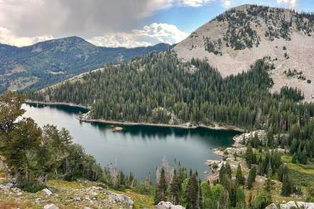
Red Pine Lake
Difficulty: Moderate to challenging | Best Time to Visit: July-September for warmest temperatures
Red Pine Lake showcases the alpine magic that makes Little Cottonwood Canyon legendary. Tucked beneath granite peaks just 30 minutes from downtown, this high-mountain lake serves up the kind of scenery that usually requires a passport to Switzerland.
Starting from the White Pine trailhead, you'll follow a well-marked path through pine and aspen forests before choosing your adventure at the trail fork (stick to the right for Red Pine). The trail gains serious elevation over its final two miles, but each step brings you closer to one of the Wasatch's most pristine alpine lakes. Once you reach the shore, a gentle loop trail invites you to explore the entire lakeside - trust us, you'll want to circle the whole thing.
Local wisdom: Pack a lunch and extra layers - even in summer, the lake's 9,600-foot elevation means temperatures can shift quickly. Morning visits often reward you with mirror-like reflections on the lake's surface.
Fun Fact: After your second bridge crossing, a stunning cascading waterfall awaits just a short trek away. Trust us—this quick detour is the perfect addition to make your Red Pine hike truly unforgettable!
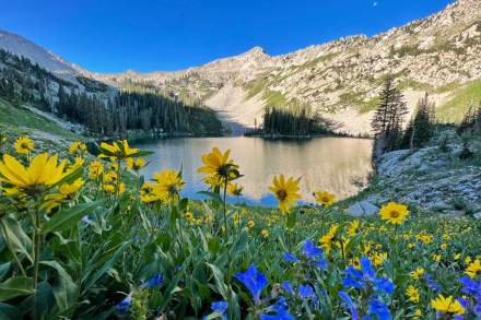
Albion Basin to Cecret Lake
Difficulty: Moderate (steady climb with rewarding views) | Best Time to Visit: July-August
The Albion Basin to Cecret Lake hike offers a quintessential Wasatch adventure with a mix of wildflower-filled meadows and breathtaking alpine scenery. This 4.5-mile round-trip trail features a steady climb, gaining 1,210 feet in elevation, making it a great option for hikers seeking a rewarding workout without being overly strenuous.
Starting at the Albion Basin trailhead (approx. 9,500 feet), the hike winds through some of Utah's most stunning wildflower displays in the summer, including Indian paintbrush, lupine, and columbine. The trail culminates at Cecret Lake, a pristine alpine treasure surrounded by towering peaks—perfect for photos or a peaceful break.
Important note: Swimming in Cecret Lake is not allowed, as it is part of the protected watershed.
Local wisdom: Arrive early to secure parking and enjoy the cooler morning air. Bring plenty of water, sturdy footwear, and an extra layer—it can be chilly at this altitude. Watch for wildlife like moose along the way, and remember that afternoon thunderstorms are common, so plan accordingly!
Lower Falls via Bell’s Canyon
Difficulty: Moderate - Hard | Best Time to Visit: Early morning for best lighting and smaller crowds. Late Spring through early Fall.
Bell's Canyon serves up classic Wasatch mountain scenery in double portions. Starting just 25 minutes from downtown in Sandy, this granite-walled canyon delivers two of Salt Lake's most stunning hiking destinations: Bell’s Canyon Reservoir and Bell’s Canyon Lower Falls
The first leg to the waterfall makes a perfect introduction to Salt Lake's mountain trails, climbing steadily alongside a tumbling stream until you reach the cascade. You'll gain about 1,500 feet in elevation over those first two miles - enough to feel like you've earned that waterfall view. Find your perfect picnic spot (there are plenty), but remember our local rule: admire the waterfall's power from a safe distance.
Important note: This trail is part of Salt Lake City's watershed. No dogs allowed, and please stay on trail to protect our drinking water.
Pro tip: The trail shifts from well-marked to more adventurous after the waterfall (watch for the sign pointing to the left). Ensure you have a map and plenty of water - this is true mountain hiking.
Donut Falls Trail
Difficulty: Easy to Moderate | Best Time to Visit: Summer and fall mornings
Donut Falls earned its name, honestly - imagine a mountain stream diving through a circular hole in solid rock. Just 40 minutes from downtown in Big Cottonwood Canyon, this family-favorite trail delivers big adventure in a kid-sized package.
The well-maintained trail meanders through forest and meadow before reaching the falls. While the path is manageable for most ages, leave the stroller at home - you'll want sturdy shoes for the rocky sections near the waterfall.
Local wisdom: This trail's popularity is well-earned, which means weekend crowds. Hit the trail for a mid-week morning adventure or arrive early on weekends to claim your parking spot. Pack water shoes if you want to get closer to the falls in summer months but always exercise caution near the water.
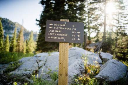
Lake Mary, Martha and Catherine
Difficulty: Easy to Lake Mary, moderate to Catherine | Best Time to Visit: July-September
The Lakes Trail at Brighton serves up not one, but three pristine alpine lakes in a family-friendly package. Starting from Brighton Ski Resort (just 40 minutes from downtown), this trail delivers high-mountain scenery from the first step - no marathon hiking required.
Lake Mary arrives after a one-mile climb, surrounded by granite peaks and summer wildflowers. Keep your camera ready - local moose often drop by for their own alpine photo ops. Got extra energy? Continue past Lake Mary to discover Lakes Martha and Catherine, each offering their own personality and perfect picnic spots.
Local wisdom: The high elevation means cooler temperatures and afternoon storms - pack layers and plan for a morning start. And yes, those wildflowers are stunning, but remember our local rule: take only pictures, leave only footprints.
Twin Lakes Pass Trail
Difficulty: Hard (altitude makes it interesting!) | Best Time to Visit: July-September
Twin Lakes Pass offers a perfect taste of high-alpine hiking without the all-day commitment. Starting at Alta Ski Area (8,530 feet), this trail instantly delivers the kind of mountain magic that usually requires hours of climbing. Even mid-summer, you'll find temperatures 10-15 degrees cooler than downtown Salt Lake.
The trail climbs steadily through wildflower-dotted meadows to a spectacular pass connecting Little and Big Cottonwood Canyons. At the top, take your pick of granite perches to soak in views stretching from Brighton to Alta. Those Instagram-worthy shots of Twin Lakes? They're all yours from up here.
Local wisdom: Start early - afternoon thunderstorms are common at this elevation. And don't forget that extra layer; even if it's 90 degrees in the valley, you might need a light jacket up here
Practical Visitor Info
Best Time to Hike
Spring to Fall: Ideal for most trails, with pleasant temperatures and clear paths.
Winter: Some trails remain accessible, but snow and ice may require extra gear. And don’t forget to check the avalanche forecast before heading out on your winter adventure—safety first!
What to Pack
Plenty of water (Utah’s dry climate can be dehydrating)
Sunscreen and a hat for sun protection
Sturdy hiking shoes
Snacks or a packed lunch
Layers (weather can change quickly, especially at higher elevations)
Pro Tip:Always check the weather before heading out—Utah’s mountain weather can be unpredictable!
The secret to Salt Lake's hiking magic is how quickly you can go from city sidewalk to mountain vista. Whether you're the type who considers a gentle stroll through Red Butte Garden a workout or someone who wants to conquer the Bonneville Shoreline Trail before lunch, we've got a path with your name on it. Imagine starting your morning with a quick 15-minute drive from downtown, stepping onto a trail that offers breathtaking Wasatch views, and being back in time for a craft coffee or local brew. Hiking here isn't just an activity - it's how we transition between urban comfort and mountain adventure, all before most cities have finished their first cup of coffee.