Allison Croghan is a TV meteorologist and news anchor turned content creator in Salt Lake City.
Maybe you’ve seen the headlines–a Super El Niño is predicted for the 2026-2027 ski season. So what does that actually mean for Utah’s iconic snow?
Whether you’re an experienced skier hoping to chase major powder or you’re a beginner learning how to ski, let’s get you dialed in for everything you need to know for this winter in Utah. You’ll be skiing the Greatest Snow on Earth™ before you know it!
What is El Niño?
When the ocean surface temperature is warmer than usual near the equator in the eastern and central Pacific Ocean, that warm water can influence weather patterns around the world. It is a natural climate pattern that typically develops every 2 to 7 years. This year is shaping up to be historic.
How does it impact Utah?
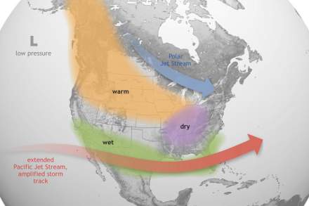
The El Niño climate pattern causes the Pacific jet stream to move further south and extend further east than usual. The jet stream impacts temperature and precipitation like rain and snow. You can think of it as a highway in the atmosphere—it flows from west to east and steers storms.
During a typical El Niño winter pattern, the northern part of the United States sees warmer-than-average conditions and the far southwest sees wetter-than-average conditions. Keep in mind, these are just common trends that have been seen in the past and not guarantees.
Generally speaking, El Niño’s impacts on Utah can be a bit unpredictable since we fall in a bit of an in-between zone.
Ok, so what’s a Super El Niño?
It’s worth noting that “super” is not an official category, but some people are calling it that because it may be an exceptionally strong El Niño this time.
Remember the ocean surface temperatures we talked about earlier? The warmer the Pacific water is compared to normal, the stronger the El Niño. Scientists measure this using a 3-month average (running mean).
The Climate Prediction Center (CPC) says the El Niño is still getting stronger and there is a greater than 90% chance of a “very strong” event during the fall and winter 2026-2027. Not only that… but the CPC says “there is a 75% chance of a historic event that would exceed the strength of previous El Niño events dating back to 1950.” So that’s why people are calling it super… this winter’s El Niño may be one for the record books. Which raises the question, does that mean Utah is in for a super snow? Let’s get into it.
Northern Utah ski resorts during strong El Niño events
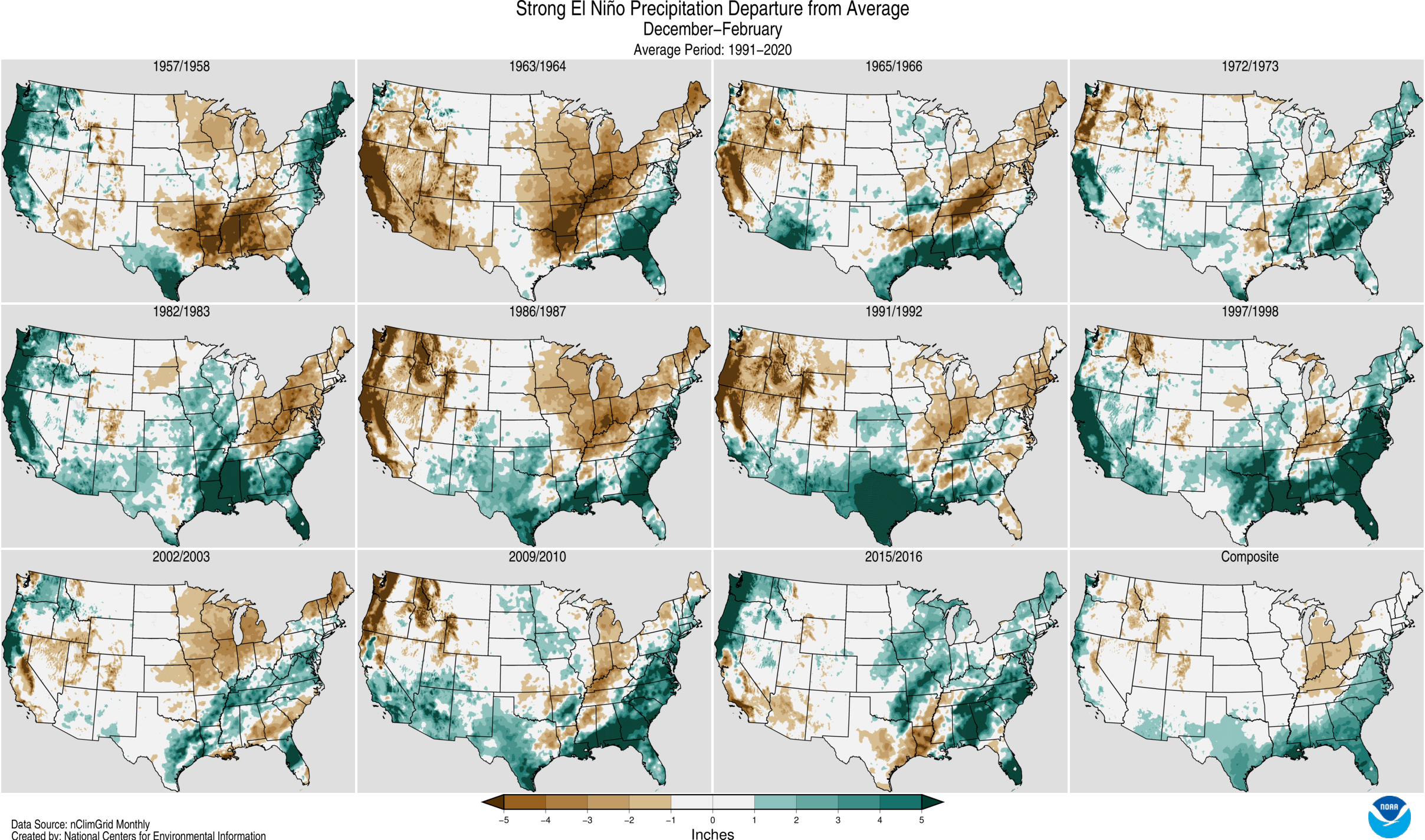
Keep in mind– no two El Niño events are exactly the same. There are many, many factors that determine how a ski season will play out. But for curiosity’s sake, let’s look back at the strongest El Niño episodes since 1950 (based on the December-January-February timeframe).
To make it easy, let’s just look at one nearby weather station (the Alta Guard station) and see how much snow it recorded for each full ski season.
1982-1983: 637.0”
1991-1992: 395.0”
1997-1998: 575.9”
2015-2016: 392.5”
It really can be a mixed bag in Northern Utah. Here’s how rain and snow compared to normal across the whole United States during strong El Niño winters. (click to enlarge)
The Greatest Snow on Earth®
Regardless of how the El Niño event pans out, Utah is known for its fantastic snow consistency and frequent powder days even on average years. There are lots of factors that come together to create legendary conditions that attract skiers and snowboarders from around the world. The high elevations, lake enhanced snow off the Great Salt Lake, frequency of storms, and fluffy snow on top of denser bases, all come together to create a great recipe for wonderful skiing conditions. And the cherry on top? There are four world-class ski resorts in Salt Lake County.
Frequently Asked Questions
Does El Niño mean more snow in Utah?
Not necessarily. Northern Utah falls in an area where the El Niño impacts (temperature, rain, and snow) can be quite variable.
How is this year different from past strong El Niños?
This year’s El Niño is expected to be exceptionally strong. It could possibly rank among the strongest El Niños on record, which makes this winter worth watching.
Why is Utah's snow so good, even in average years?
The Cottonwood Canyons frequently get “Goldilocks Storms.” Snowstorms that aren’t too big, aren’t too small, but are just right. That’s a term coined by University of Utah Atmospheric Sciences Professor Jim Steenburgh. He says you need three ingredients for perfect powder: the right amount of new snow, a soft underlying surface below, and right-side-up snowfall for ski flotation (lighter snow on top of heavier snow). The microclimate of the Cottonwood Canyons helps make the Goldilocks Storms possible.
When will we know what kind of ski season Utah is going to have?
We won’t know until the season is well underway. January and February are usually the peak ski months in Utah. But even on a low year, there’s still a lot of snow to be skied in Utah. Last year’s 2025-26 ski season was Alta’s least snowy on record but they still picked up 321” of snow (including a 15” powder day on closing day).